Posts

Hiking at Bukit Dinding

Image
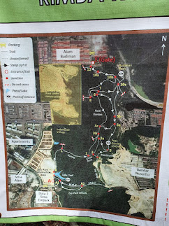
It is one of Kuala Lumpur's tallest hills, standing at 291 metres. It is less than 10 minutes from Ampang LRT station and is located in Wangsa Maju. The trailhead is simple to locate. Simply search for the roadside stand selling coconut shakes. The trailhead is right across the street from the stall. Alternatively, you can visit Kompleks Sukan MSN Setiawangsa. From there, travel straight for approximately a kilometre till you come across this coconut shake stand. Because you're trekking on a concrete and asphalt road all the way to the peak, where two telecommunication towers are located, the walk is rather straightforward. The route is fairly steep at first, but it is a gradual ascent for the most of the journey. According to my Garmin, the entire distance to the peak is roughly 2.5km, and doing one circle (up and down) at an average speed takes less than an hour. Beginners and intermediate hikers can benefit from this workout. Views from the summit is blocked by trees and the

Bukit Wawasan, Puchong Hiking

Image
 The trail's beginning took me a little by surprise. From the beginning, the route began to rise steadily. Although not as steep or long-stretched as Bukit Botak, it was still enough to have my heart racing. Because there were more rocks than tree roots, the route was dry and sturdy; I can image it being quite muddy and difficult when rainy. In reality, the route was not shaded for the first section. I was delighted I had brought my hiking shoes with me. We were rewarded to a gentler track after that ascent until we came to a visible fork. We chose the right-hand route because there appeared to be more people at the time. It appeared fine for a while until we were greeted by another lengthy stretch of ascent. This ascent, on the other hand, was a little different from the first. It was a shaded area. It was more difficult. It was a little longer. I didn't want to look up because my heart couldn't stand the thought of how much farther I had to climb.  We got a view on the wa

Hiking Bukit Besi Alam Damai

Image
 Bukit Besi Alam Damai is a 291 m (955 ft) high hill in southeast Kuala Lumpur's Sungai Besi / Alam Damai district, just inside the Federal Territory city borders. It appears as a 4 square kilometre stretch of grass surrounded by dwellings on Google Earth. Three telecommunications towers are located on the peak. Hikers must begin their ascent in the north east corner, where Persiaran Alam Damai meets Jalan Alam Damai, because the western side of the hill is flanked by the Sungai Besi army camp, which is off-limits to civilians. The route then climbs up to a hill from where you may receive your first views of the city. There appear to be several distinct ways to follow in certain spots, but the rule of thumb is to pick the path that appears to be the most frequented and continue climbing. This spot is called Check Point 1 on some blogs. Rest here if you need to but this is a fairly short hike, about 3km. It only took me 1 hour to reach the top (with short breaks for photos and drink

Hiking to Bukit Botak, the Bald Hill

Image
 On the route to Pucak Alam, you will pass by a lovely green hill with a "bald" top. The natives refer to it as Bukit Botak, which means "Bald Hill." My family and I went there to investigate Bukit Botak since it is so distinct from the other neighboring hills with beautiful foliage. Gundul Hill can be climbed from two points: the UiTM campus and a construction site, which is where we started. Because both places are on private property, you must obtain permission from the owner to enter. The hill is owned by the state (owned by government). Because there are few trees along the route, we began our hike around 7:30 a.m., before the sun rose too high in the sky. We began by taking a 15-minute stroll in a wooded area near the foothill. Keep your eyes peeled for a snake hiding nearby. There is no such thing as a forest leech. The hiking track has a gentle incline. The route is roughly 1.5 kilometres long and takes less than an hour to complete. It is not difficult, but

Sungai Pisang Waterfall/Hiking

Image
Sungai Pisang Waterfall was visited by my family and me. It's in the Selangor town of Gombak. Because of its cool and peaceful natural surroundings, this is a popular site for hikers, picnickers, and campers. My family and I arrived at the area at 9 a.m., and after gathering our food and tools, we began hiking to the waterfall. Sungai Pisang Waterfall charges RM5.00 for parking. Fortunately, the weather on that particular day is sunny. We must trek across a river, through a forest, and up hills to reach the waterfall. Sungai Pisang Waterfall is also my first time hiking there. The majority of tourists will snap a photo in front of the tunnel since it indicates that you had previously hiked to Sungai Pisang Waterfall. Because there is no light when travelling through the tunnel, you will need to use a torchlight if the weather is gloomy. It took us 45 minutes to successfully reach the waterfall. It is packed around the waterfall, with people picnicking and enjoying the cool wind fro

Setia Alam Community Trail

Image
The Setia Alam Community Trail is a critically threatened woodland. Hikers did not establish the trails. Instead, it was done by bikers! This community route is located in the new housing development of Setia Eco Park and is suited for walkers of all fitness levels! Peak Garden, at 250 metres above sea level, is the highest peak in Bukit Cherakah Forest, followed by Bukit Sapu Tangan, at 241 metres above sea level. The Trail Map Setia Alam Community Trail is discovered by the locals themselves. They have made significant contributions to the trail's preservation over the years, particularly in the form of signs. As a result, losing your route is extremely unusual, yet it has happened in the past. Route A More crowded Less steep ascend Nice lookout halfway to Peak Garden More exposed Route B Less crowded Steeper Has a beautiful lake  Slippery Along The Trail Warm up before the trek to minimize cramping by stretching your hamstring and calf muscles. Remember to wear appropriate hikin